more midwest paddling...
Midwest Whitewater River Inventory (Wisconsin, Minnesota, Michigan, Illinois & Indiana)
Paddles and Pathways Through the Upper Midwest - Kirk Schutte
Rapids Riders (Upper Midwest)
Minnesota DNR Canoe Routes
Minnesota Rivers page from
Midwest Mountaineering (Rivers and Creeks in and around Minnesota)
Wisconsin Whitewater Rivers Guide and
Gage Page (Wisconsin, Michigan and Illinois)
Wisconsin Attractions:
Canoeing and Kayaking Rivers
Flambeau River and
Flambeau River State Forest, Wisconsin
Recreational Dam Releases on the Black River at Lake Arbutus, and on the Wisconsin River at Wausau
Northwoods Wilderness Outfitters Iron Mountain, MI
(Pine, Brule, Michigamme and Menominee Rivers)
The Rucksack, Central Upper Peninsula Group, Michigan Chapter of the Sierra Club
(Paddlesports destinations in Michigan, Wisconsin, Minnesota, & Ontario, Canada)
BWCA, Superior National Forest, CanoeCountry.com and
QueticoPark.com
(Everything you'll need to plan and outfit a trip to Boundary Waters/Quetico or Minnesota's North Shore)
Canadian Canoe Routes
Canadian Recreational Canoeing Association
Great Canoeing Canoe trip liveries and outfitters, from the
Go Play Outdoors Network
Voyageurs National Park (map), Minnesota,
from the National Park Service
Park Net, and
Sylvania Wilderness
(map), Ottawa National Forest, Michigan, from the USDA Forest Service
Apostle Islands National Lakeshore (map), Wisconsin, and
Isle Royale National Park
(map), from the National Park Service
Park Net.
And be SURE to visit
www.isleroyale.info and check the Isle Royale Boaters Association and CoastWatch - Great Lakes surface water temperatures.
Aurora Forecast and Aurora Viewing
America�s public lakes, rivers, and seashores from Recreation.gov.
Chicago Area Paddling/Fishing Page
Prairie State Canoeists (Illinois)
Vermillion River, (Illinois); Virtual tour at River's End Midwestern Paddlesports;
Yahoo Group message board
Arkansas Floater's Kit, ARKANSAS RIVERS & CREEKS http://www.yournet.com/floatkit/
Missouri Whitewater Association
http://www.missouriwhitewater.org/
Mo Creekin'
www.coe.missouri.edu/~chrisa/mocreekin/
Ozark Whitewater - Bill Herring http://www.ozarkpages.com/whitewater/
Floating the Ozarks - Bill Herring http://www.ozarkpages.com/floating/
Missouri Canoe & Floaters Association
http://missouricanoe.org/
Missouri Outdoors http://www.fultonmo.net/mo.htm
South Central River Rat Resource Page - the rivers and creeks of the Ouachita Mountains of Arkansas and Oklahoma,
as well as the Ozarks and Texas hill country
Kansas City Whitewater Club
Kansas Paddler - a greater Kansas area River Runner's Web Site and the
OFFICIAL Home of the Kansas Canoe Association
Nebraska's Canoe Trails from the Nebraska Game and Parks Commission
Canoeing & Kayaking in South Dakota, the Big Sioux and Missouri, from South Dakota State Parks
All About Rivers - Virtual Rivers Guidebook
American Whitewater - Rivers - search by state
http://www.americanwhitewater.org/rivers/
GORP - Outdoor and Recreational Travel Resources
http://www.gorp.com/gorp/location/us/us.htm
Nationwide Rivers Inventory (NRI) - National Park Service
http://www.ncrc.nps.gov/rtca/nri/
Paddling.net - Places to paddle www.paddling.net
PhatEye.com Nationwide River Resources
http://www.phateye.com/index.asp
StateGuide.com - "destination research made simple"
http://www.stateguide.com/
Trails.com Trail Finder (hiking, biking, paddling, skiing) http://www.trails.com
Ucancanoe - Internet Canoe Route Database - Canoe routes and journals submitted by paddlers http://ucancanoe.net
IOWA RENTALS/OUTFITTERS:
Appleby Canoe Rental, 21430 River Road, Monticello, IA 52310
Ames Outdoor Gear, 4723 Lincoln Way, Ames (515-292-2276)
Bickford Canoe Rental, Maquoketa River at Monmouth (563-652-5855)
CanoeSport Outfitters, Lake Aquabi and Indianola (1-800-257-6080)
Chimney Rock Canoe Rental & Campground, Bluffton (877-787-2267)
Garst Farm Resort, Middle Raccoon River at Coon Rapids
Hruska's Canoe Livery, Upper Iowa at KendallVille (563-547-4566)
ISU Recreation Services, Ames (students and staff only)
Johnson Canoe Rental, 2643 West Ravine Road, Decorah, IA 52101
Lynn County Parks,
on the Wapsipinicon at Pinicon Ridge Park
Raccoon River Retreats, Middle Raccon at Redfield (515-833-2636)
Randy's Bluffton Store,
Upper Iowa River at Bluffton (563-735-5738)
River Basin Canoe & Kayak, Burlington (800-748-3712)
Rock-n-Row-Adventures, Iowa River Tube Rides
Seven Oaks Scenic River Floats, Boone (515-432-9457)
Turkey River Canoe Trips, 117 South Main, Elkader, IA 52043 (1-800-250-2466) Clayton County
Twin Lakes Bait Shop, Iowa River near Eldora (641-858-2084)
Upper Iowa Canoe Rental, PO Box 301, Decorah, IA 52101
RIVER ACCESSES (Iowa DNR designated and others)
Boone River:
Riverside Park - In Webster City off East 2nd near R33 & on the West side of the river;
Briggs Woods - On Hwy 17 2 miles South of Webster City - follow road through park to landing near 17 bridge;
Albrights - 270th St south of Briggs (access is river-left below the bridge);
Bever Bridge - On 280th St east of D41/17 and west of D46/R27
(take out above the bridge, river-left on Inkpaduta Rd);
Tunnel Mill - Off R27 South of bridge;
Bells Mill - North from D56 between R21 & R27;
Boone Forks - Take D54 North from Stratford, turn North on Shiloh just before D54 crosses the Des Moines River.
Note: The mileage listed between Bever Bridge and Tunnel Mill should be 5.6, not 7.6 (The mileage was not adjusted when Bever Bridge was added to the Canoe Guide). Mileages between Tunnel Mill and Bells Mill, and between Bells Mill and Boone Forks may both be long. Expect these sections to take an hour or less under spring streamflows.
Des Moines River:
Norton's Ford - From E18 bridge, west ~1.5 miles to J Ave, north 1 mile to "T", east on 118th to Juniper Rd,
south to undeveloped access. Park on dead-end road.
Fraser ramps - on Juniper Road, south from E18 west of bridge or north from Fraser south of bridge.
Waterworks Ramps - Off E26 northwest of Boone (currently unmarked). Upstream ramp is north of E18,
downstream access is south of E18 at end of road (turn off E26 east of bridge & follow road past wellfields).
Riverbend Ramp - Just north of US Hwy 30 west of river.
See Des Moines River Waypoints for a listing of access points, dams, portages, and bridges with GPS coordinates.
Shell Rock River:
Strand Park - north of Plymouth on S56. Access is east of the bridge.
Skunk River: See Story County's Upper Skunk River Canoe Trail (map, 268 kb)
Turkey River:
Gilbertson Park - East of Elgin on B64;
Frieden Park - On C1X/Chariot Rd Northwest from downtown Elkader & accross river from
Big Spring Trout Hatchery - off Big Spring Rd 4 miles North of Elkader on X16;
Ten (Seven) mile Bridge - approximately 3 miles upstream from Frieden on Cable Ave;
Motor Mill Access - Take C1X from Hwy 13 on the North edge of Elkader 4 miles to Galaxy Rd,
follow Galaxy 3 miles to Motor;
Garber Bridge - South edge of Garber on X41.
See Explore the Turkey River
Volga River:
Klocks Island Park - On Hwy 93 just West of Fayette & Hwy 150;
Langeman's Ford - On Hemlock Road 1 mile north of C24 (Kornhill Road) SE of Fayette;
Volga River State Recreation Area - 2.5 miles north of Hwy 93 on Hwy 150.
(Turn at Ivy Road, Access is on road south of campground);
Volga River Access - On Heron Road just south of Ivy Road on the East edge of the Volga River State Recreation Area
("Lima" on DeLorme map);
"Grannis Creek" - State Access Area - On Fox Road between Volga River SRA & Wadena
- take Fox Road East from intersection of Heron and Ivy Roads (access to the Volga may be on private property);
Osborne Outdoor Education Center Park - On Hwy 13 five miles southwest of Elkader;
Garber Bridge (Turkey River) - South edge of Garber on X41.
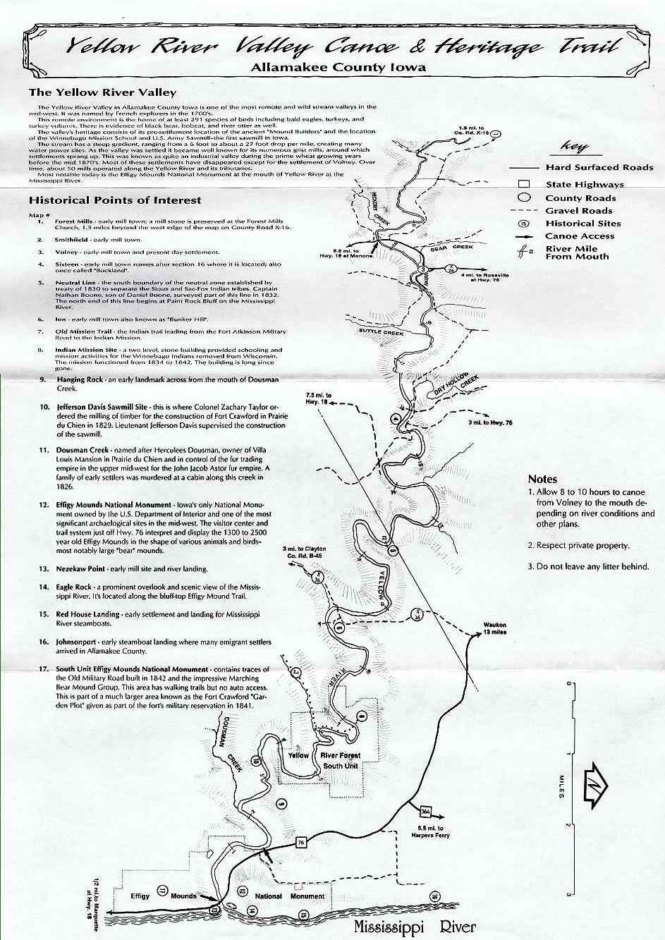
Yellow River:
Volney Bridge - Southwest of Volney on X26 - or use bridge at Big Foot Rd Southeast of Volney;
Sixteen Bridge - on Linton Drive just East of X32 and Old Sixteen Rd
- take Bigfoot Rd East to Linton, or Old Sixteen Rd South from Hwy 76 (& just west of B25);
Ion Bridge - On Ion Rd/X36 off Hwy 76 - or use public areas on Old Mission Rd, which follows the river approximately
two miles downstream from Ion Bridge;
Hwy 76 Access - Just North of Smokey Hollow Rd and Effigy Mounds;
Yellow River Access - On the Mississippi just south of the 76 bridge.
Note: There is a concrete ford/farm road crossing midway between Sixteen and Ion (near the section line) which
should be portaged or scouted. (See Yellow River, April 7th, 2000)
Get your Yellow River Valley Canoe & Heritage Trail brochure from the
Allamakee County Economic Development & Tourism Commission, 1-800-824-1424.
If you paddle in NE Iowa, you should pick up a "Fayette, Winneshiek, Allamakee & Clayton Counties, Iowa" map (by Area Map Service, Cincinnati, Ohio) from an area business. This map includes the Upper Iowa, Yellow, Turkey, Little Turkey and Volga Rivers, all secondary roads (named) and crossings. Similar maps are available in Wisconsin.
You may also want the state "Atlas and Gazetteer", available at many sporting goods stores. See DeLorme at Maps
Iowa County Conservation Boards (addresses, phone numbers, email & websites) http://george.ecity.net/iaccb/ccbs.html
MEANDERED RIVERS
In Iowa, on those rivers designated as meandered (see list below), the state owns the stream bed up to the normal high water mark. On those designated as non-meandered, the state owns the water only, and the adjacent land owners own the stream bed.
It's often said that if you step out of your boat on a non-meandered river, technically you are trespassing. This may not be so, as this could be considered a part of "navigating" (see below). But it's never been tested in court.
There are (portions of) 13 interior rivers classified as meandered:
Cedar, lower 157 miles beginning near Cedar Falls
Des Moines, 278 miles,
mouth to confluence of east & west forks
East Fork DM, mouth to north edge of Algona, 39 miles
West Fork DM, mouth to Emmetsburg, 44 miles
Iowa, lower 123 miles beginning west of Marengo
Maqouketa, lower 26 miles beginning near Maquoketa
Little Maquoketa, lower 2 miles
Nishnabotna, lower 6 miles
Raccoon, mouth to Dallas-Polk County line, 13 miles
Skunk, lower 61 miles (none of the South Skunk)
Turkey River, lower 58 miles beginning near Clermont
Upper Iowa River, lower 6 miles
Wapsipinicon, lower 98 miles beginning near Central City
"Meandered" is a surveyor's term going back to when the state was first surveyed.
The Iowa DNR has this to say about public waters: "Water occurring in any river, stream or creek having definite banks and bed with visible eveidence of the flow of water is declared to be public waters of the state of Iowa and subject to use by the public for navigation purposes in accordance with law".
Iowa further defines "navigable waters" as "all lakes, rivers and streams, which can support a vessel capable of carrying one or more persons during a total of six months period in one out of every ten years". The US Supreme Court has ruled that a stream may be navigable even if it contains some obstructions.
Where a public road crosses a stream, the road right-of-way extends across the stream and it's banks. You may encounter and cross a fence in the right-of-way, but, as with those encountered in a stream, do not damage it.
See Meandered Rivers on the IA DNR Environmental Protection Division website, RECREATIONAL NAVIGATION, and
Who Owns the Rivers? at the
Iowa Fishing and Floating Guide.
| 